
Highlights

Highlights
Citation
Notes: trans. Richard Brookes, 3d ed., vol. 2
Publication Location: London
Year: 1741
Item Location
Exhibit: Galileo and China
Section: The Role of the Jesuits
Summary
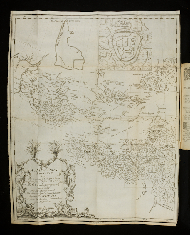
Du Halde lived in China for nearly 30 years. This work recounts the story of Candida Xu, who collaborated with the Jesuit astronomers as had her grandfather, Xu Guangki. For a foldout map of China, du Halde drew upon the Kangxi atlases of 1717 and 1721. Around 1688, at the instigation of the Emperor Kangxi, Le Comte and a dozen other Jesuits began a 30-year project to map the entirety of China. They plotted longitude and latitude coordinates for more than 600 locations based on the meridian of the Paris Observatory. As a result, for the rest of the century both Chinese and European geographers had access to maps constructed from the same geographical data.
Related Items
Theme(s): Geography, History, International Studies, Women and Science
Geographical Region(s): Asia, China, India, London, Europe, Korea
Resource Type: Book
Chronological Period: 18th century
Resource Type: Book

